E-Flora BC: Electronic Atlas of the Flora of British Columbia

Packera pseudaurea (Rydb.) W.A. Weber & Á. Löve
Streambank Groundsel
Asteraceae (Aster family)

Introduction to Vascular Plants

© Reg Newman  Email the photographer   (Photo ID #12231)

E-Flora BC Static Map
Distribution of Packera pseudaurea
Click here to view our interactive map and legend
Details about map content are available here
Click on the map dots to view record details.

SUBTAXA PRESENT IN BC
Packera pseudaurea var. pseudaurea

Species Information

Click on the image below to view an expanded illustration for this species.


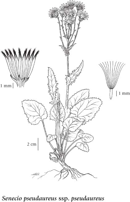
General:
Perennial herb from a fibrous-rooted, short, ascending or horizontal rhizome or woody stem-base; stems erect, solitary, branched above, glabrous to nearly glabrous, 20-70 cm tall.
Leaves:
Basal leaves heart-shaped, round, elliptic to egg-shaped or oblanceolate, stalked, 2-20 cm long including the stalk, 1-6 cm wide, toothed, lightly white woolly-hairy at first, soon becoming glabrous; stem leaves few, oblanceolate, raggedly toothed, progressively reduced upwards, becoming unstalked.
Flowers:
Heads few to many on hairy stalks in a clustered inflorescence; involucres 5-8 mm tall; involucral bracts lanceolate, sometimes purplish-tipped, glabrous to sparsely long-hairy, margins translucent; bracteoles few, inconspicuous, purplish-tipped; ray flowers yellow, mostly 6-10 mm long; disk flowers yellow.
Fruits:
Achenes oblong, glabrous; pappus of white hairlike bristles.

Source: The Illustrated Flora of British Columbia

Habitat / Range

Moist meadows, streambanks, and forests from the montane to subalpine zones; common in S BC east of the Coast-Cascade Mountains, becoming rare northward; E to S MB and S to MO, CO and CA.

Source: The Illustrated Flora of British Columbia

Ecology

Ecological Framework for Packera pseudaurea

The table below shows the species-specific information calculated from
original data (BEC database) provided by the BC Ministry of Forests and Range.
(Updated August, 2013)

Site Information
Value / Class

Minimum

Average

Maximum

Elevation (metres) 405 1398 2525
Slope Gradient (%) 0 11 100
Aspect (degrees)
[0 - N; 90 - E; 180 - S; 270 - W]
0 182 360
Soil Moisture Regime (SMR)
[0 - very xeric; 4 - mesic;
8 - hydric]
1 4 8
Modal Nutrient Regime
Class
D
Number of field plots
 species was recorded in:
484
Modal BEC Zone Class
ESSF
All BEC Zones (# of stations/zone) species was recorded in: AT(2), BWBS(11), ESSF(156), ICH(55), IDF(82), IMA(2), MH(1), MS(141), PP(5), SBPS(3), SBS(13), SWB(3)

Taxonomic and Nomenclatural Links

Additional Photo Sources

General References